
Survey Options
Surveying is a valuable tool that can be needed for many reasons. That is why we offer boundary surveys, lot surveys, parcel splits, boundary adjustments, easements, Certified Survey Maps (CSM's), topographic surveys, and subdivisions. I am licensed in both MN and WI.


Boundary and Lot Surveys
You may need a boundary or lot survey to find out where your property lines are. This is used for many reasons such as building, fencing, and just general knowledge.
Parcel Splits or CSM's
Parcel splits occur most often when land is being sold off in pieces instead of in one lot. The CSM's are needed in certain circumstances, but similar to parcel splits.
Topographic Surveying
Topographic surveys are used to map elevations. This service is used most often for building purposes.
Boundary Adjustments
Boundary adjustments are common when there are encroachment issues with neighbors. This would help to fix any issues that have arisen.

Easements
Easements are a fairly common need for property owners. They are needed when your land is not accessible and you need to create a legal description that crosses another property for access to your own.
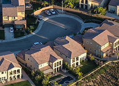
Subdivisions
Subdivisions are smaller lots that are for residential neighborhoods. Essentially one larger lot is subdivided into several smaller lots.